
Help.NGO and HOT collaborated to strengthen emergency response efforts through drone technology and open mapping. From hurricane recovery in Acapulco to forest fire assessments in Ucayali, their partnership accelerates access to critical post-disaster imagery. These joint actions enable rapid damage assessment, informed decision-making, and more effective humanitarian coordination.
Help.NGO is an international non-governmental organization specialized in emergency response, preparedness, risk mitigation, and prevention, and has spent over a decade working to reduce the effects of natural disasters, man-made conflict, economic disparity, and climate change.
Among other areas of expertise, Help.NGO subject matter experts leverage drone technology not only in the midst of an emergency but throughout the entire disaster lifecycle. This shared focus on the humanitarian issue has led to several meaningful collaborations between Help.NGO and HOT.
Acapulco, Mexico
%2011.25.34%E2%80%AFa.m/png)
Images contributed to OpenAerialMap.org in Acapulco, 2024. Explore them here.
Help.NGO and HOT have been collaborating for several years, mostly remote but also in the field. One of their first joint efforts took place during the response to Hurricane Otis in the state of Guerrero, Mexico, from October–November 2023 and continuing through much of 2024. These targeted emergency responses are HOT’s specialty, aimed at delivering updated cartography in the shortest possible time, allowing authorities and humanitarian organizations to promptly attend to the population and the different dimensions of recovery. But this implies a great difficulty because time and effort are spent looking for post-disaster aerial images for detailed damage diagnosis, one of the most valuable and difficult-to-obtain inputs.
In a coordination chat implemented by the organizations themselves – the first days of the response to the disaster were lacking a centralized dialogue space – Mr. Andres Gueverra, a Help.NGO subject matter expert and operations lead, joined the conversation. He shared that he was already on the ground in Acapulco, generating aerial imagery of strategic areas of the city at the request of local responders. He also offered to support other stakeholders involved in managing this complex emergency.
In this way, the LAC Hub and the group of organizations on the field had access to post-disaster aerial images in a very short time, something essential for the contribution that HOT can provide to other organizations, as they allow the geospatial identification of destroyed buildings and other characteristics necessary for the actions of humanitarian organizations and the government itself, capturing it on the OpenStreetMap map and thus making this data available to even more actors, for present and future uses.
Visualization: Orthophotos generated and uploaded to OpenAerialMap for public and open access.
At the same time, the National Center for Disaster Prevention (Cenapred), sent personnel to the field and also directed drone flights, obtaining images that were added to those of Help.NGO. This created a collaborative dynamic of shared efforts and results. These were complemented by the analyses made by Copernicus and other organizations, to automatically estimate the level of destruction, and guide further observations that could be relevant to other actors. With this timely exchange of resources—both the imagery and the mapping derived from it—it became possible to quickly assess which infrastructure had been destroyed, which remained intact, and which could be repurposed as shelters or collection centers.
Thanks to this rapid and efficient intervention by Help.NGO, the organizations on the ground were able to have recent images that, together with those of Cenapred, allowed them to adequately distribute their actions in the territory and optimize resources.
HOT used the imagery uploaded to the OpenAerialMap platform and immediately linked it to Tasking Manager projects to map the precise polygons of destroyed buildings. These were then cross-referenced with layers of public infrastructure commonly used as collection centers, using the DENUE database from INEGI as a reference—such as schools, sports facilities, public markets, and health centers. This process required additional effort to accurately pinpoint the location of these facilities, as their original geolocation data was often imprecise. In this task, the drone imagery proved essential for validating and refining the data.
In this way, it was possible to help various organizations and the state and city governments in a very concrete and timely manner in things such as deciding the distribution of drinking water by placing water tanks in public markets that had not suffered damage.
Ucayali, Peru

Forest fires in San Francisco, Ucayali, Peru. Drone mapping images from Help.NGO.
The second field major collaboration took place in the context of the forest fires in the Peruvian Amazon in September 2024. HOT was aware that members of the OSM Peru community were working with local communities directly affected in the Ucayali region, specifically the Shipibo – Konibo Native Community of Santa Clara de Yarinacocha.
While OSM Peru was developing a workshop for the collection of drone photographs (orthophotos) of the areas burned during the fires, our direct contact with members of Help.NGO allowed us to inquire whether their help was possible to generate post-disaster images (in areas already left behind by the fires, although the widespread fire continued), and their response was again immediate.
We coordinated the connection between Help.NGO and the OSM Peru people in Ucayali, thus ensuring that they had contact on the ground. We then also coordinated the authorization of a local authority so that they could have a formal request for a visit and so that the entry of the professional drones would not have problems when passing through customs.
Additionally, we connected this combined Help.NGO and OSM Peru team with other local organizations in addition to those that were already part of the aid consortium (Alianza Arkana, the Bilingual Institute and the UNIA Student Association) such as Pro Purús and the Association of Youth for Democracy, in order to reach more affected communities.
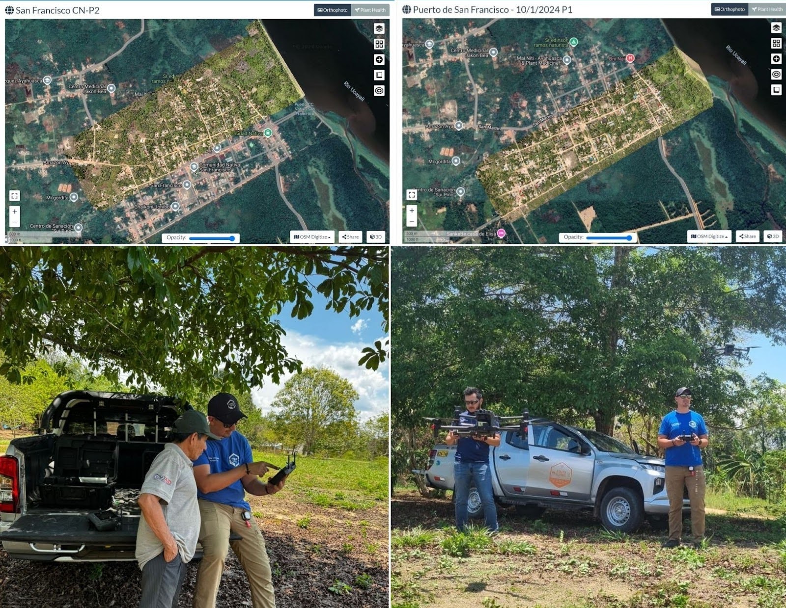
Drone images taken at WebODM. Help.NGO team in the community of San Francisco, Ucayali.
The Help.NGO team spent several days in the regions affected by the forest fires, going out into the field very early to obtain the best possible quality of the images, even reaching remote places where the fires were still active. This considerably expanded the territorial reach of the OSM Peru initiative and the local community.
The resulting images were processed in WebODM and shared with the OSM Peru team and the local communities and organizations, which allowed them to more accurately recognize the extent of their own affected territory. They also shared an impact analysis of the impact for a joint effort to identify affected areas for reporting to local authorities.
Johnattan Rupire, representative of OSM Peru, was very grateful for the support, because as already mentioned, the deployment of the Help.NGO team allowed access to more remote communities that would otherwise have been more difficult to reach, and also allowed obtaining higher quality and more precise images, as well as up-to-date images.
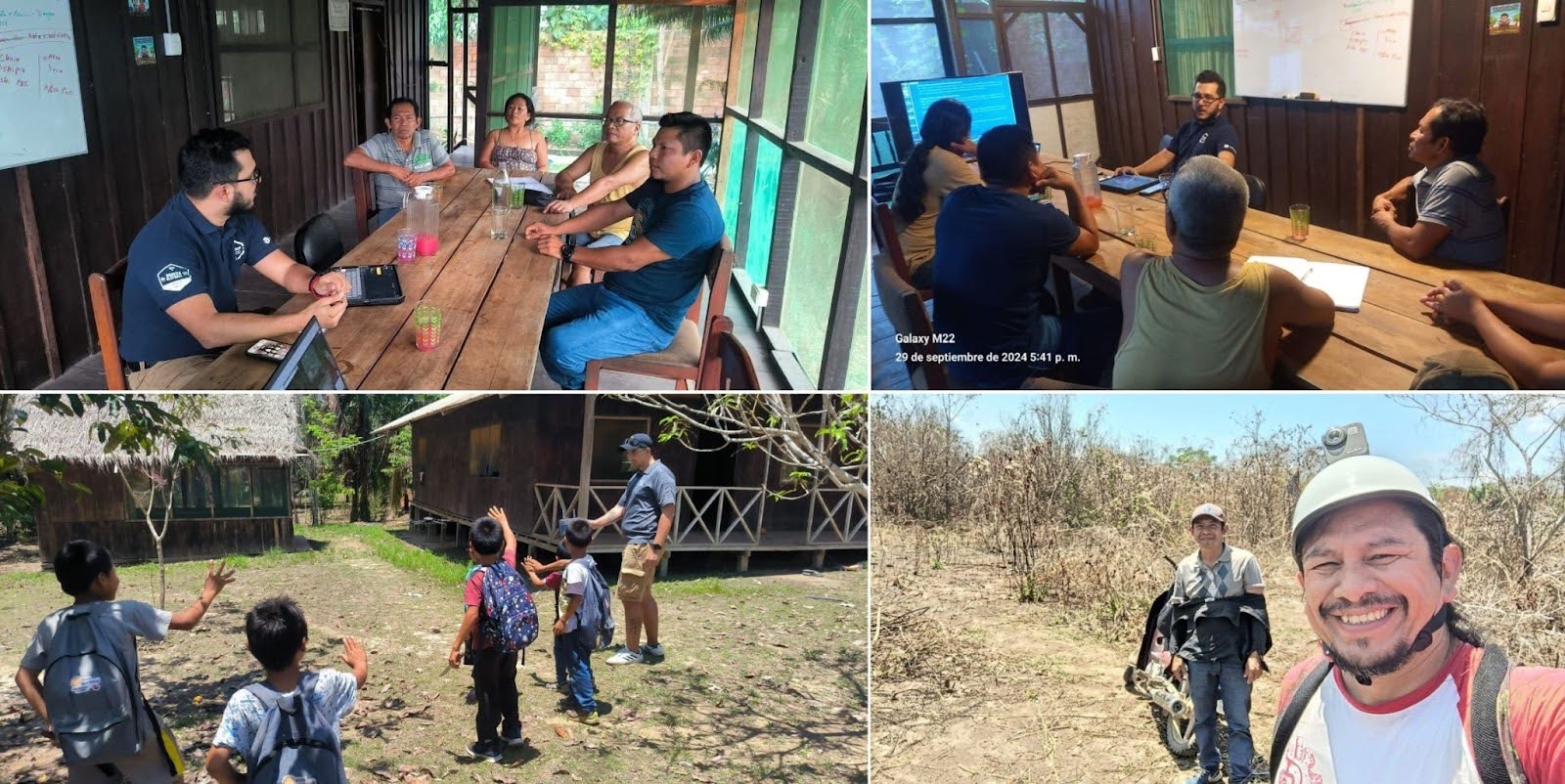
Help.NGO member presenting the work done to representatives of local communities and organizations. Help.NGO member in the community of Santa Clara, Ucayali. Johnattan Rupire from OSM Peru taking pictures with a GoPro.
These joint mapping actions are an example of how technology, collaboration and commitment can make a difference in the response to a humanitarian crisis. By combining the knowledge and skills of different actors, it has been possible to generate valuable information that will contribute to the recovery of the affected territories and the construction of a more sustainable future. We hope that these joint actions will be repeated in the future, as it allows us to provide more precise help to the communities in emergency situations that we serve.
Preliminary digital geospatial action is a crucial support stage for humanitarian action in the field, since it allows us to better understand the reality and organize activities. It is completely dependent on field images, whether street level or high-resolution areas, so the work of Help.NGO is crucial and we invite more like-minded actors to get in touch, helping each one to make their work more flexible thanks to the contributions of others.
from Humanitarian activities – Techyrack Hub https://ift.tt/bmRrqjf
via IFTTT

